

Lets Talk Soil
Soil! Sticky or grainy, soft or hard, wet or dry, dark or light… What is this stuff? Though it surrounds our everyday experiences, with so many different feels and forms, understanding soils can be a lot to keep track of… though remarkably easy to track through the house -cue my three kiddos. In addition to its varied qualities, soil is vital to our existence. Most of the food we eat is dependent on soil. Much of what dies, or is eliminated as waste, is broken down by soil biology. We build our homes on soil. We build our houses from the trees that take root in soil. Soil stores carbon…You get the idea.
So, when I hit the road to meet up with Marissa Theve, BLM soil scientist, for our hike at Cascade Head, I felt a flutter of anticipation. I was going to unlock the mysteries of soil, or at least get the scoop on this dirty little topic (pun intended).
With a rainbow overhead on the drive out to the Oregon Coast, it seems like a good omen. But you tell me. Join me on a hike with Marissa Theve- soil scientist.

The Hike
Hike at a Glance
Trailhead: Cascade Head Trail- South Trailhead. Knight Park.
Miles: 6.2 miles
Elevation Gain: 1,500 ft
Notes: Pit toilets are available at the trailhead. No dogs are allowed on the trail.
The Cascade Head Hike starts at Knight Park, just north of the Salmon River. In fact, the river is visible from the trailhead. And a part of what makes this particular hike so appealing are the views of the Salmon River Estuary experienced further up the trail. But I am getting ahead of myself…
What is soil?
Before we move on, we need to answer one little question- “What the heck is soil anyway?” Is the sediment at the bottom of the Salmon River soil? Is beach sand soil? Yes!!!
According to Marissa, soil “is a living habitat.” It is a diverse biome teaming with life forms, such as bacteria, nematodes, fungi, and plant roots. The interactions between all these organisms and their environment change the soil and aids in its formation. Though some soils may not be as developed as others- like a sandy beach- if they fit this general definition, they are in fact soils! O.K. back to the hike…
Turning our backs to the river, Marissa and I followed a muddy path that runs adjacent to Savage Rd and alongside a small stream.
Elk- soil construction or destruction?

Before long we came to a clearing where a herd of Elk were grazing. A thought came to my mind- “Could the Elk be changing the soil?”
Soil compaction is one of the biggest impacts we see on Oregon soils. Compaction may occur anytime a large animal or machine or even a person exerts force on soil. Compaction is a problem because it changes the structure of soil. In general, we want soils that crumble like the crumbs of a cookie- this provides pore space for air and water, and habitat for soil organisms- which in turn makes the soil more fertile. Compaction destroys structure; compressing soil into sheets below its surface.
In addition, loss of vegetation through grazing, can also impact the soil by increasing erosion. Soil that is not covered by plants, or other materials, is susceptible to erosion by wind and water. The loss of the top layer of soil isn’t a huge deal on a hiking trail, but it is very problematic if you ever want to grow anything on the soil again. Topsoil, or A horizon, is the most important plant supporting part of soil.
Luckily, Elk herds tend to move around a lot, minimizing their impact on the land. They also release a lot of organic matter in their excrement- building up the organic material that makes soil fertile. People on the other hand… well, please tread lightly.

Eventually, we left the roadside, and headed straight into a lush conifer forest. At this point, the trail steepened.
Into the woods
I love this part of the hike. The trees are big and greenery is everywhere. And it IS A CLIMB!
I asked Marissa what someone might learn about soils in a forested place like this. The answer was simple- “look at the plants.” For example, she explained, a plant like Salal- an evergreen shrub with pink bell shaped flowers and leathery leaves- is more likely to be found in gravelly, dry sites. While Oxalis- a forest cover plant with three heart-shaped leaves arranged like a clover- is found in wetter soils.
The tall Sitka Spruce trees and sword ferns of the forest surrounding us gave an indication that the soil was deep, rich and moist.
The diversity of plant life in a forest is also important for understanding its soils- as plant diversity is closely linked with soil diversity, which in turn results in healthier, richer soil. Organisms that live in soil produce chemicals like glomalin, or “soil glue,” that helps maintain good soil structure and health.
What texture are you?

Another clue about the nature of the forest soil we found at our feet. Each time we stepped into a wet patch of soil, it coated our shoes and suctioned us to the ground. The trail was filled with icky, sticky MUD!
Soils can generally be characterized by their relative proportion of sand, silt, and clay particles. Each type of particle is a different size – sand being the largest and clay the smallest. These particles form from the weathering of different rocks under a variety of conditions. These particles also give soils some of their properties, like ability to drain or hold water.
The sticky soil that clung to our feet, is a pretty good indicator that the soil we were walking on was more clayey than sandy. Sandy soil would simply fall away. Clay soil can be hard to wash off.
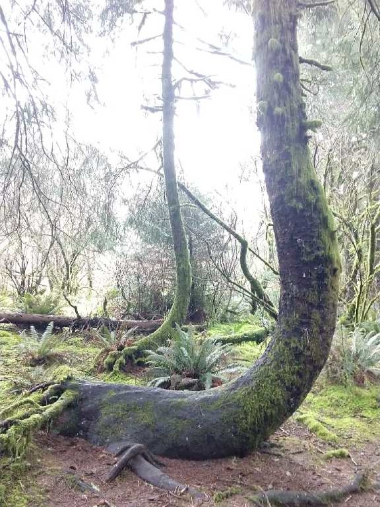
Clay soils are also more prone to erosion- soil movement, including landslides, or mass movement, of soil. An indicator of this sort of downhill movement of soil- called pistol butting – and can be observed on many forested trails in the Oregon Coast Range. If trees are growing in an area where the soil has moved, or creeped downhill, the root systems gets shifted and the trees must correct their growth to continue to reach upwards. The result is a forest of J-shaped trees. We found one example of pistol-butting during our hike.
About a mile and a half into the hike, the scenery changed. Instead of a lush conifer forest, the trail continued through a dense broadleaf riparian forest. We crossed a few bridges as we made our way over a system of streams.
Lets talk “parent material”

At this point, it might be useful to point out a bit about the geological history of Cascade Head. Cascade head is comprised of several geological units. Formed from ancient oceanic basalt volcanic rocks AND marine sedimentary rocks- like sandstone and siltstone- that were uplifted as tectonic plates collided along the western edge of North America.
When Marissa and I left the forest, and entered the open meadow that the hike is famous for, the complexity of the Cascade Head geology became clear. Looking behind us, a view of both the conifer forest and the broadleaf forest lay nicely into the background of the open meadow environment. The stark contrast between these different areas provides evidence that the geology- and soil- of each environment is unique.
Marissa explained- the basalt rocks found on Cascade Head are the base geological material- also called parent material- for the conifer forest we hiked through. Basalt rocks weather into clay soils that can retain more water than other soils, supporting large, deep rooted trees.
At the same time, sedimentary rocks weather into drier, less fertile soil, unable to support trees. The sedimentary rocks are the parent material for the meadow.
While the broadleaf forest relies on soils with properties somewhere in between.
What the ClORPT is up with Oregon soils?
Diversity of soils is not something that can only be experienced at Cascade Head. In Oregon, ten of twelve possible soil orders- the most general classification of soils- are represented in the state. The reason for the diversity of Oregon soils lies in the great variability in soil forming factors that exist across Oregon’s landscape. These factors can be remembered by the mnemonic- Cl-O-R-P-T: Climate, the presence of Organisms, Relief (or topography), Parent material, and Time.
If you consider just terrain and climate, it is easy to understand Oregon’s soil diversity. Oregon has mountains, valleys, floodplains, and more. It is both wet (in the west) and dry (in the east). Thus, the soils of one corner of the state will look completely different from another corner.
Views from the meadow
As we hiked across the meadow we could see more examples of how soil forming factors were responsible for creating the thin, rocky soils.

We saw signs of bioturbation by burrowing animals- probably gophers. Organisms, in general, are extremely important for soil formation. I hypothesized that the gophers here might help with soil formation as they would aid in mixing of organic matter into the subsoil and bringing mineral matter toward the surface where it can be weathered. However, it should be noted that too much mixing, like you see with tilled farm fields, can result in loss in soil fertility as organic matter is oxidized in the air.
As we took in the views, the wind picked up and eventually it started raining. On a coastal headland like this, erosion by wind and rain are also important factors for soil formation.
At several points along the trail, we were able to see exposed areas of rock, or parent material, where the rest of the soil had been eroded away.
Is soil like an Ogre? Does it have layers?

Eventually, we reached the lower viewpoint where you can look down a cliffside to the ocean. I asked Marissa, if she noticed anything interesting about the spot.
Looking out to the northside of the cliff, Marissa pointed out an area where you could see the soil was developing distinct layers.
You see, if you dig into the soil, you will find that it is not uniform throughout. Soil, as it forms in place, will develop layers called horizons that have unique characteristics, like color and texture.
Normally, it is difficult to observe these layers without digging into the soil. Road cuts often provide another glimpse into the world underground.

The cliffside soil was in the process of developing into a spodosol, one of the twelve orders of soil. There are three main bands of color in a spodosol-see the image above. The slightly darker area in the profile is the A horizon, or topsoil; this is where all the organic matter resides making it dark. The bright red color, making up most of the image, is the B horizon, or subsoil. The E horizon is the “elluviating layer” between the A and B horizons of the soil. The minerals that give soil color, like aluminum and iron oxides, travel through this layer and settle in the B horizon below, giving it a vibrant color.

From the lower viewpoint, the trail continues at a steep incline. Still out in the open, gusts of wind hurried us along the heavily eroded trail until we reached the well marked “summit.” Views are not significantly better here than the lower viewpoint. We didn’t stay long at the top before heading down the way we came.
Time to head home
Soon, we were back to the car, ready to head home.
Time is the last of the listed soil forming factors. It takes a long time to build soil- hundreds to thousands of years- it is considered nonrenewable for that very reason. For comparison sake, we completed our hike between 3-4 hours.
We exist so far outside the timescale of soil formation. Yet, soil erosion and degradation is rampant throughout the world and is happening quickly. We are losing way more soil than we are building on a daily basis.
Wait, don’t worry! All is not lost. With soil scientists, like Marissa Theve, on the case, we are getting better and better at managing our soils. We are looking at new ways to enhance soils with amendments, like biochar, and changing our practices, like farmers moving to no-till agriculture, in order to enhance and preserve soil.
As inhabitants of this planet, we can continue to make ourselves aware of our own impacts on the soil. As hikers, for example, we can stay on the trail and respect sensitive soil ecosystems.
After dropping Marissa off at her car, I drove home. My head was swimming with soil facts as I walked in the door and greeted my husband. He gave me a hug. “You smell like the Earth,” he commented. Coincidence? I think not.
Marissa Theve is a soil scientist for the BLM Northwest Oregon District. She is responsible for soils of the Cascades and Mary’s Peak resource areas. She has also worked for NRCS Soil Survey Office in Connecticut. Interview and hike with Marissa was conducted outside of working hours.